LabeledPolygram
限定名称: manim.mobject.geometry.labeled.LabeledPolygram
- class LabeledPolygram(*vertex_groups, label, precision=0.01, label_config=None, box_config=None, frame_config=None, **kwargs)[源码]
基类:
Polygram构建一个多边形,其不可达极点处包含一个标签框。
- 参数:
vertex_groups (Point3DLike_Array) – 传递给
Polygram构造函数的顶点。precision (float) – PolyLabel 算法使用的精度。
label_config (dict[str, Any] | None) – 包含标签配置的字典。仅当
label的类型为str时应用此配置。box_config (dict[str, Any] | None) – 一个包含背景框配置的字典。
frame_config (dict[str, Any] | None) –
包含帧配置的字典。
注意
PolyLabel 算法要求每个顶点组形成一个闭合环。如果输入是开放的,
LabeledPolygram将尝试闭合它。这可能导致多边形自相交,从而产生意想不到的结果。提示
请确保精度与您的输入比例相对应!例如,如果您的多边形边界框从 0 延伸到 10,000,则 1.0 或 10.0 的精度就足够了。
kwargs (Any)
示例
示例: LabeledPolygramExample 
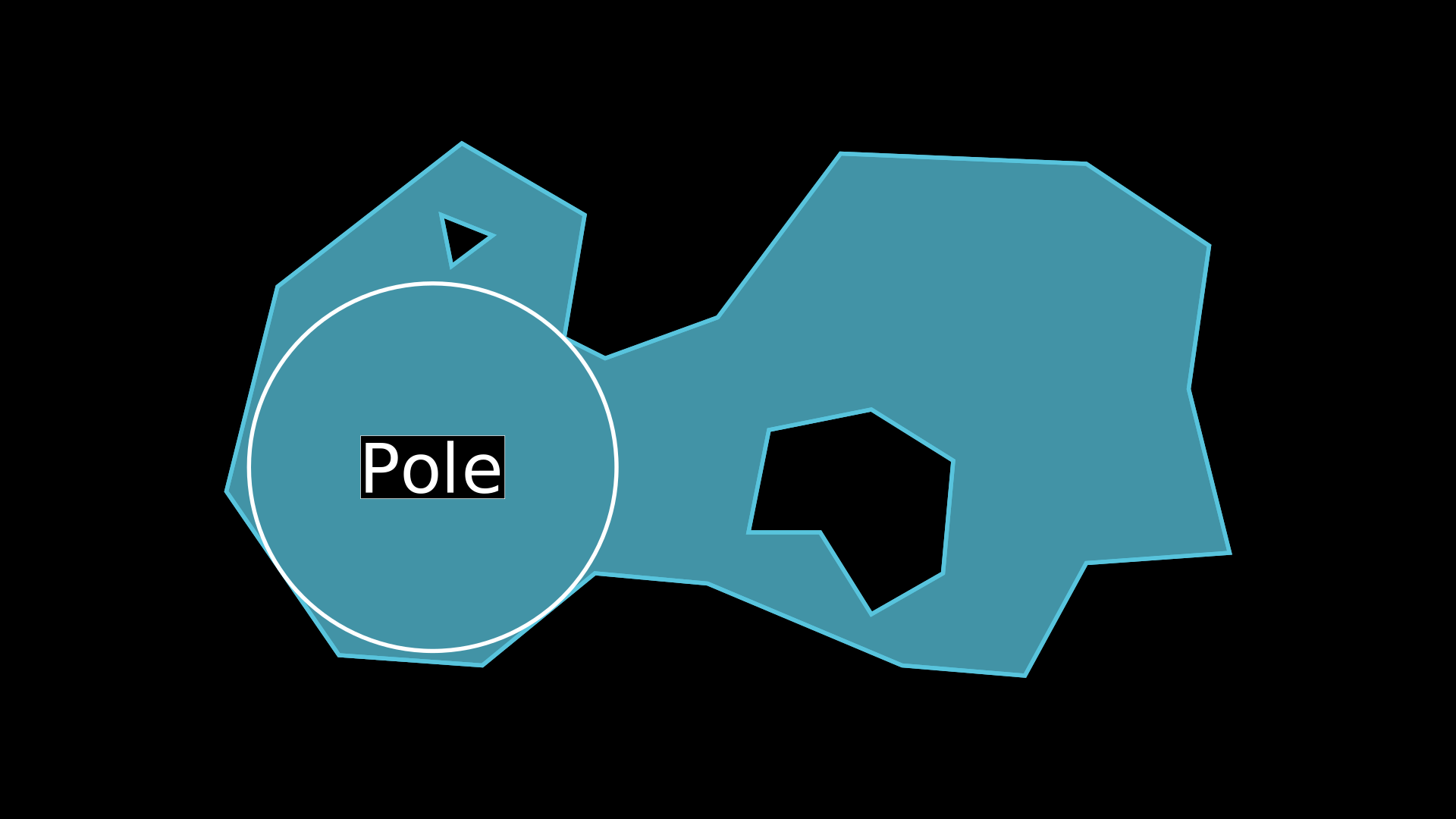
from manim import *

class LabeledPolygramExample(Scene):
    def construct(self):
        # Define Rings
        ring1 = [
            [-3.8, -2.4, 0], [-2.4, -2.5, 0], [-1.3, -1.6, 0], [-0.2, -1.7, 0],
            [1.7, -2.5, 0], [2.9, -2.6, 0], [3.5, -1.5, 0], [4.9, -1.4, 0],
            [4.5, 0.2, 0], [4.7, 1.6, 0], [3.5, 2.4, 0], [1.1, 2.5, 0],
            [-0.1, 0.9, 0], [-1.2, 0.5, 0], [-1.6, 0.7, 0], [-1.4, 1.9, 0],
            [-2.6, 2.6, 0], [-4.4, 1.2, 0], [-4.9, -0.8, 0], [-3.8, -2.4, 0]
        ]
        ring2 = [
            [0.2, -1.2, 0], [0.9, -1.2, 0], [1.4, -2.0, 0], [2.1, -1.6, 0],
            [2.2, -0.5, 0], [1.4, 0.0, 0], [0.4, -0.2, 0], [0.2, -1.2, 0]
        ]
        ring3 = [[-2.7, 1.4, 0], [-2.3, 1.7, 0], [-2.8, 1.9, 0], [-2.7, 1.4, 0]]

        # Create Polygons (for reference)
        p1 = Polygon(*ring1, fill_opacity=0.75)
        p2 = Polygon(*ring2, fill_color=BLACK, fill_opacity=1)
        p3 = Polygon(*ring3, fill_color=BLACK, fill_opacity=1)

        # Create Labeled Polygram
        polygram = LabeledPolygram(
            *[ring1, ring2, ring3],
            label=Text('Pole', font='sans-serif'),
            precision=0.01,
        )

        # Display Circle (for reference)
        circle = Circle(radius=polygram.radius, color=WHITE).move_to(polygram.pole)

        self.add(p1, p2, p3)
        self.add(polygram)
        self.add(circle)
示例: LabeledCountryExample 
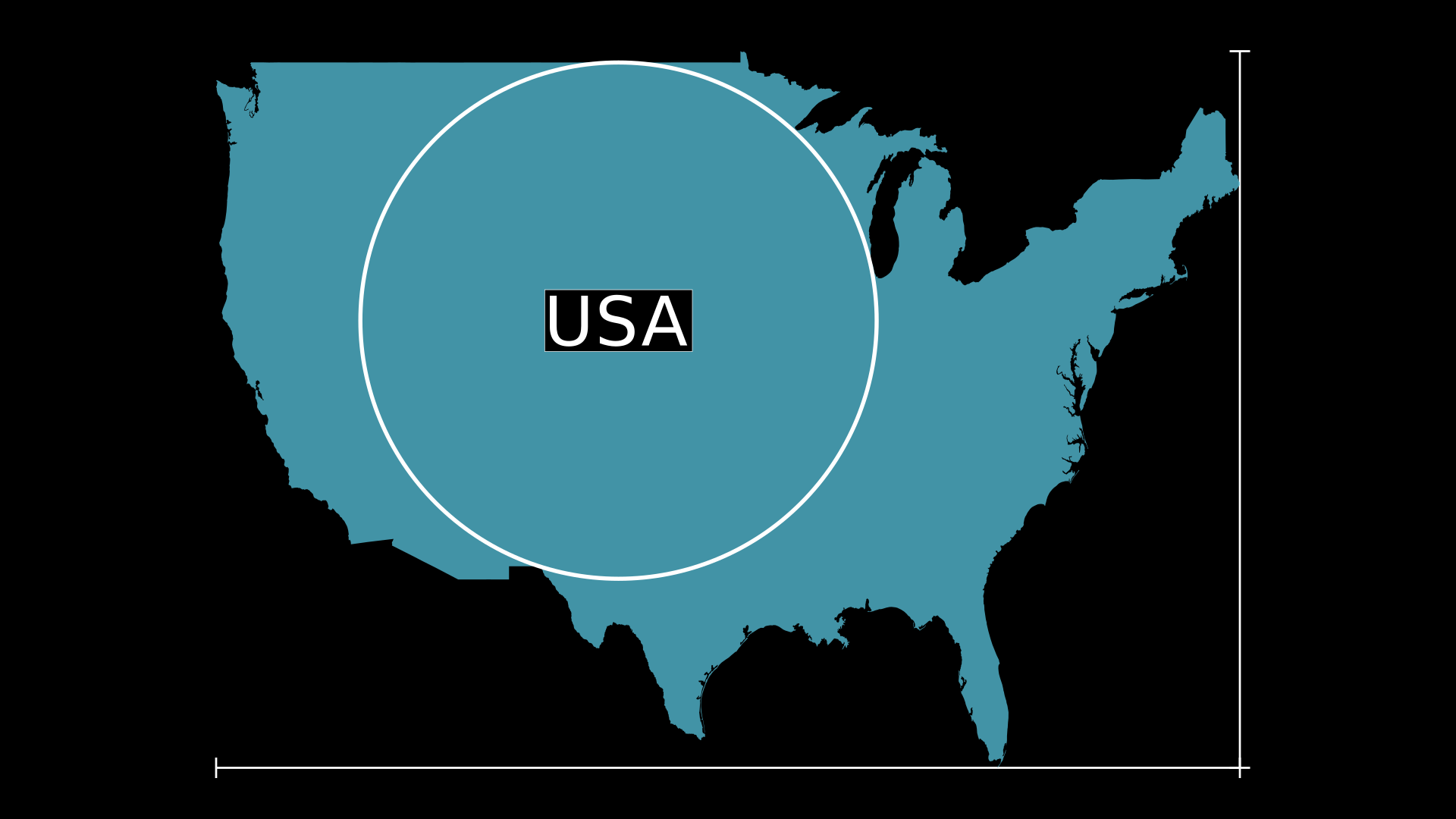
from manim import *

import requests
import json

class LabeledCountryExample(Scene):
    def construct(self):
        # Fetch JSON data and process arcs
        data = requests.get('https://cdn.jsdelivr.net.cn/npm/us-atlas@3/nation-10m.json').json()
        arcs, transform = data['arcs'], data['transform']
        sarcs = [np.cumsum(arc, axis=0) * transform['scale'] + transform['translate'] for arc in arcs]
        ssarcs = sorted(sarcs, key=len, reverse=True)[:1]

        # Compute Bounding Box
        points = np.concatenate(ssarcs)
        mins, maxs = np.min(points, axis=0), np.max(points, axis=0)

        # Build Axes
        ax = Axes(
            x_range=[mins[0], maxs[0], maxs[0] - mins[0]], x_length=10,
            y_range=[mins[1], maxs[1], maxs[1] - mins[1]], y_length=7,
            tips=False
        )

        # Adjust Coordinates
        array = [[ax.c2p(*point) for point in sarc] for sarc in ssarcs]

        # Add Polygram
        polygram = LabeledPolygram(
            *array,
            label=Text('USA', font='sans-serif'),
            precision=0.01,
            fill_color=BLUE,
            stroke_width=0,
            fill_opacity=0.75
        )

        # Display Circle (for reference)
        circle = Circle(radius=polygram.radius, color=WHITE).move_to(polygram.pole)

        self.add(ax)
        self.add(polygram)
        self.add(circle)
方法
属性
animate (动画)用于动画化
self的任何方法的应用。animation_overrides (动画覆盖)颜色depth (深度)mobject 的深度。
fill_color (填充颜色)如果存在多种颜色(用于渐变),则返回第一种颜色
height (高度)mobject 的高度。
n_points_per_curve (每条曲线的点数)sheen_factor (光泽因子)stroke_color (描边颜色)width (宽度)mobject 的宽度。
- _original__init__(*vertex_groups, label, precision=0.01, label_config=None, box_config=None, frame_config=None, **kwargs)
初始化自身。有关准确签名,请参阅 help(type(self))。
- 参数:
vertex_groups (Point3DLike_Array)
precision (float)
label_config (dict[str, Any] | None)
box_config (dict[str, Any] | None)
frame_config (dict[str, Any] | None)
kwargs (Any)
- 返回类型:
无